
He Ara Kotahi Bridge and Manawatū River
He Ara Kotahi Bridge and Manawatū River at sunset.
Creator:
Place: Awapuni, Palmerston North
Date: April 1, 2026

He Ara Kotahi Bridge and Manawatū River at sunset.
Creator:
Place: Awapuni, Palmerston North
Date: April 1, 2026

This image is believed to have been taken by Palmerston North Engineer Frank (Frances Leslie) Berry.
Creator: Berry Family
Date: 193X

This image is believed to have been taken by Palmerston North Engineer Edwin Daniel Berry or his son Frank. It depicts three young boys, all of whom appear in several images in the Berry Family Collection. Although unknown, they appear to be conte...
Creator: Berry Family
Place: Palmerston North
Date: 191X
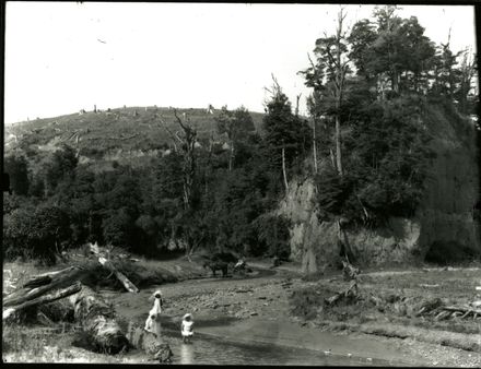
Unidentified children playing in a river (possibly the Pohangina River).
Creator: Charles E. Wildbore
Place: Pohangina
Date: unknown

This image was taken for a story that ran in The Manawatu Evening Standard on 16 January 1961: "Many Feilding people spent Saturday afternoon quietly beside the Oroua River picnic spot at Menzies Ford."
Creator: Manawatu Evening Standard
Place: Glen Oroua, Manawatu
Date: January 16, 1961


This hand-tinted postcard shows the Manawatū Gorge around 1900.
Creator: Unknown
Date: circa 1900

This 'obstacle course' appeared on the pavement by He Ara Kotahi in mind August 2021, during the Delta-lockdown that month. The walkways around the Manawatū river were incredibly busy during lockdown, and this was a kind-hearted initiation of f...
Creator: Juliet Galuszka
Place: He Ara Kotahi, Manawatū River, Palmerston North
Date: August 26, 2021

Pictured is a view of the Manawatū River walkway at a time of development. A crane can be seen near the beach, as well as other construction equipment.
Creator: David Foster
Place: Te Motu o Poutoa (Anzac Park / Pork Chop Hill)
Date: 1986

A City Council bus coming over the Manawatu bridge into Fitzherbert Avenue. A Municipal bus service was established in Palmerston North in 1921.
Creator: Unknown
Place: Fitzherbert Bridge, Palmerston North
Date: 1950

A view of the Fitzherbert Bridge over the Manawatū River from the Victoria Esplanade gardens. One of a set of images of Palmerston North, produced for sale.
Creator: Unknown
Place: Palmerston North
Date: circa 1940

The Upper Manawatu Bridge taken at the Woodville end of the Manawatu Gorge Walk. Taken on 15 July 2017 while the Gorge Road was closed due to a large slip and 1 day after a large southern storm had passed over the country. Gorge Road has now been ...
Creator: Evan Greensides
Place: Manawatu Gorge
Date: July 15, 2017

Manawatū River Walkway on a Sunny day in April.
Creator: Jennifer Kilsby
Place: Palmerston North
Date: April 2018

A mayoral picnic held at Tiritea Valley during J A Nash’s term as Mayor of Palmerston North (1908-1923). Nash is standing second row from front, with box under right arm and hand on left knee. His wife, Elizabeth Nash (nee Grater) is second from r...
Creator: Whalley and Co., Crown Studios,
Place: Turitea, Palmerston North
Date: circa 1910

The man in the centre is Mr Samuel Jickell, who was the Palmerston North Borough Engineer and on the right is Mr Christian Voss. The date of this photograph suggests these men were on their way to the construction site of the second dam at Turitea.
Creator: Unknown
Place: Turitea Road, Palmerston North
Date: circa 1907

This photograph shows two unidentified men transporting provisions by horseback, across the ford before "Black Ridge". Kahuterawa Valley is located near Palmerston North in the foot of the Tararua Ranges. One of the earliest European owners of the...
Creator: Unknown
Place: Kahuterawa Valley, Manawatu
Date: circa 1896

View looking downstream of College Creek, Tararua Forest Park. College Creek forms part of the Mangahao #2 Dam to College Creek loop track, with Burn Hut lying on top of the ridgeline at the halfway point along the track..
Creator: Evan Greensides
Place: Tararua Forest Park
Date: January 22, 2018

This view appears to have been photographed on the same occasion and from the same view as 2011P_Fx53_004596. The three flaxmills are 1. Foxton Mill of A King & Co in right background with white water tank. 2. Star Mill, G Coley in right centre wi...
Creator: G W Anderson
Place: Foxton, Manawatu
Date: circa 1910

The 1953 flooding of the Manawatu and Oroua Rivers was one of the worst on record for the area. This photograph shows Bourke's Drain during the Rangiotu Flood, taken from the Main Road looking towards Palmerston North.
Creator: J Moore
Place: Manawatu
Date: February 1953

The 1953 flooding of the Manawatu and Oroua River was one of the worst on record for the area. This photograph shows an unknown farm being swamped by floodwaters during the Rangiotu Flood.
Creator: J Moore
Place: Manawatu
Date: February 1953

Okere Falls Power Station on the Kaituna River, near Rotorua. This photograph was created by William James Young in the early 20th century. A large variety of subjects are depicted in the collection, but family, rural life and travel are the most ...
Creator: William James Young
Date: 1899 to 1901

This photograph shows a small waterfall on the river relating to the Power Scheme. The Mangahao Power Station provides hydroelectric power and is situated near the town of Shannon. It serves Wellington, Horowhenua, Taranaki, Hawkes Bay, and the Wa...
Creator: Unknown
Place: Horowhenua Region
Date: circa 1924

This postcard is thought to be a view of the Manawatu Gorge. The Manawatu Gorge (in Maori Te Apiti, meaning 'The Narrow Passage') runs between the Ruahine and Tararua Ranges of the North Island of New Zealand, linking the Manawatu and Hawke's Bay ...
Creator: Unknown
Place: Manawatu
Date: circa 1890

The paved clearing is the Anzac Park parking lot. The square two-storey building in the left side of the image is the golf club clubhouse.
Creator: Clarice Parlane
Place: Palmerston North
Date: 196X

Bridge over the Ohau Channel at Mourea, which connects Lake Rotorua and Lake Rotoiti. This photograph was created by William James Young in the early 20th century. A large variety of subjects are depicted in the collection, but family, rural life ...
Creator: William James Young
Date: 1900 to 1932

The 1953 flooding of the Manawatu and Oroua River was one of the worst on record for the area. This photograph shows the debris left by the floodwaters. An eyewitness said local boys made makeshift rafts from the branches.
Creator: J Moore
Place: Manawatu
Date: February 1953

Shown here is the damaged lower dam structure at Mangahao. The Mangahao Power Station provides hydroelectric power and is situated near the town of Shannon. It serves Wellington, Horowhenua, Taranaki, Hawkes Bay, and the Wairarapa. After being del...
Creator: Unknown
Place: Horowhenua Region
Date: September 1923

An aerial view of He Ara Kotahi Bridge. The bridge opened on 7 June, 2019.
Creator: Palmerston North City Council
Place: Palmerston North
Date: May 14, 2019

The Kawhatau area, north of Rangiwahia in the Ruahine Ranges, was very isolated with few services. The land was largely used for sheep farming and hunting.
Creator: Unknown
Place: Palmerston North
Date: 189X

This postcard is thought to be a view of the original wooden Fitzherbert Bridge, which was built in 1877. It would be taken from a an area upstream, looking across to Fitzherbert and the Tararua Ranges
Creator: Unknown
Place: Manawatu

The Manawatu River appears to be in flood in this photograph. Scaffolding is still in evidence so presumably the photographs were taken just prior to the official opening in July 1935. This replaced the original structure built in 1877. It was con...
Creator: Snapshots Unlimited
Place: Fitzherbert Bridge, Palmerston North
Date: circa 1935