Found 21 results

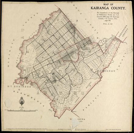
Kairanga County Map, 1916

This map shows Kairanga County as it stood in 1916.

The Kairanga County Council was established in 1902 as a result of the amalgamation of the Manawatū Road Board and the Fitzherbert Road Board. The County amalgamated with the Manawatū County in ...

Creator:      
Place:          Kairanga County
Date:          1916

Aerial photo of Palmerston North in 1945 – no. 2 South-East quarter of City

A black and white aerial photograph of Palmerston North and some surrounding areas. This photo is part 2 of a set of 4. Streets, buildings and other landmarks are visible. The layout and extent of the City at this date can be clearly seen.

Creator:      Department of Lands and Survey, Wellington
Date:          November 18, 1945

Plan of Town and Suburban Sections: Palmerston North, Manawatu

This map shows one of the earliest layout plans for Palmerston North. It includes mostly sections south of present day Main Street (labelled Great Northern Road). The map shows some of the landscape features underlying the present day city. Scale ...

Creator:      Henry Jackson, Chief Surveyor
Date:          circa 1872

Plan, Native Reserve on Block IV, Kairanga

Plan of a Native Reserve on Block IV of the Kairanga District, dated January 1888. Surveyed for M Prendergast by H S Palmerston. Comprises 2 seperate 150 acre allotments along the Manawatu River near Linton and bounded by the Kautepawa Stream.

Sc...

Creator:      H S Palmerston
Place:          Linton
Date:          January 1, 1888

Plan of Lower Aorangi River

Plan of the Aorangi River showing the confluence with the Oroua River, Te Pora Stream and Manawatu River in Rangiotu. Dated March 1885.

Scale is 20 chains to 1 inch.

Creator:      Palerson & Perth
Place:          Rangiotu
Date:          March 1, 1885

Palmerston North City Boundary alterations 1877 to 1967

A map showing the various boundary changes to Palmerston North City since 1877. Includes street names and section & lot numbers. Black ink on paper. Shows boundary changes from the years 1877, 1949, 1953, 1961 and 1967. Scale 20 chains: 1 inch.

Creator:      Palmerston North City Council
Place:          Palmerston North
Date:          June 24, 1968

Aerial photo of Palmerston North in 1945 – no. 3 North-West quarter of City

A black and white aerial photograph of Palmerston North and some surrounding areas. This photo is part 3 of a set of 4. Streets, buildings and other landmarks are visible. The layout and extent of the City at this date can be clearly seen.

Creator:      Department of Lands and Survey, Wellington
Date:          November 18, 1945

Aerial photo of Palmerston North in 1945 – no. 1 North-East quarter of City

A black and white aerial photograph of Palmerston North and some surrounding areas. This photo is part 1 of a set of 4. Streets, buildings and other landmarks are visible. The layout and extent of the City at this date can be clearly seen.

Creator:      Department of Lands and Survey, Wellington
Date:          November 18, 1945

Aerial photo of Palmerston North in 1945 – no. 4 South-West quarter of City

A black and white aerial photograph of Palmerston North and some surrounding areas. This photo is part 4 of a set of 4. Streets, buildings and other landmarks are visible. The layout and extent of the City at this date can be clearly seen.

Creator:      Department of Lands and Survey, Wellington
Date:          November 18, 1945

The Papaiōea Clearing shown in relation to original streets of Palmerston North

Map of the Papaiōea Clearing shown in relation to the original streets of Palmerston North surveyed between 1866 - 1875. Based on Mitchell's map of 1866, Jackson's map of 1875 and Scott's map of 1881. The street names drawn on the map are present ...

Creator:      M B
Place:          Palmerston North
Date:          October 1989

NZ Cadastral Map - Town Series: Palmerston North Map 2

Four first edition maps in a series covering Palmerston North and close environs. Map two covers Roslyn, Milson and Kelvin Grove areas of Palmerston North, and areas towards Bunnythorpe in Kairanga Council. Map shows: Section and Lot numbers of pr...

Creator:      Lands and Survey Department, New Zealand
Place:          Palmerston North
Date:          September 1, 1960

Flaxmills of Makerua Swamp

This hand-drawn map of the Makerua Swamp (now Opiki District) shows the approximate location of the flax mills that once operated on the banks of the Manawatu River.

Creator:      Ian Matheson
Place:          Opiki, Manawatu
Date:          1978

AA Map of the Manawatū

The cover of this map reads, "Manawatu Map Leaflet - Day Tours Radiating from Palmerston North. Compiled and Published by The Automobile Association (Manawatu) and (Auckland)."

Creator:      The Automobile Association
Place:          Manawatū
Date:          1940 to 1959

NZ Cadastral Map - Town Series: Palmerston North Map 3

Four first edition maps in a series covering Palmerston North and close environs. Map three covers Hokowhitu and Terrace End in Palmerston North, and the Fitzherbert (Aokautere) area, which was then in the Kairanga County. Map shows: Section and L...

Creator:      Lands and Survey Department, New Zealand
Place:          Palmerston North
Date:          September 1, 1960

NZ Cadastral Map - Town Series: Palmerston North Map 1

Four first edition maps in a series covering Palmerston North and close environs. Map one covers Milson in Palmerston North, and the Town of Bunnythorpe and Kairanga areas of Kairanga County. Map shows: Section and Lot numbers of properties; size ...

Creator:      Lands and Survey Department, New Zealand
Place:          Palmerston North
Date:          May 1, 1960

Map of the Borough of Palmerston North, District of Wellington, New Zealand

Map of Palmerston North showing streets and individual sections with some section numbers and areas visible. Scale 6 chains : 1 inch.

Creator:      H J Wylde, Civil Engineer, Authorised and Licensed Surveyor, Palmerston North
Place:          Palmerston North
Date:          1906

NZ Cadastral Map - Town Series: Palmerston North Map 4

Four first edition maps in a series covering Palmerston North and close environs. Map four covers Takaro, West End, Awapuni and Awatapu areas of Palmerston North, and some of Fitzherbert and Kairanga County areas. Map shows: Section and Lot number...

Creator:      Lands and Survey Department, New Zealand
Place:          Palmerston North
Date:          May 1, 1961

Plan of the Borough of Palmerston North District of Wellington, 1895

A large map of the subdivion of Palmerston North showing section, lot and area for many sections. Scale 6 chains : 1 inch.

Creator:      H J Wylde, Civil Engineer, Authorised and Licensed Surveyor, Palmerston North
Place:          Palmerston North
Date:          1895

Plan of Town and Suburban Lots: Township of Palmerston, Upper Manawatu

This map shows one of the earliest layout plans for Palmerston North. It includes the names of many of the landowners written on the sections they held and extensive anotations detailing sections purchased for public schools and other uses. Land a...

Creator:      James Mitchell
Place:          Palmerston North
Date:          July 24, 1866

Narrow search results